
 Image 1 of 1
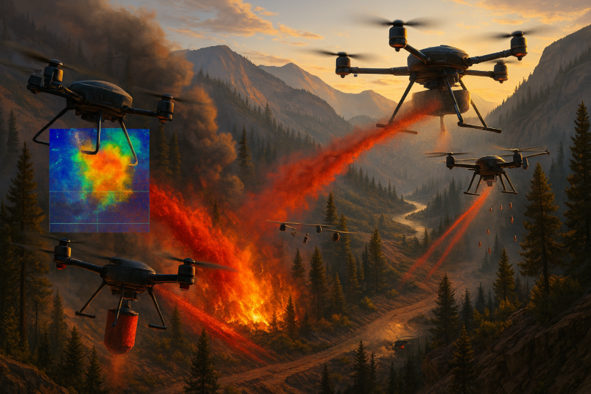
Drone + AI Wildfire Response
Thermal detection, mapping, and directed suppression with autonomous mission control
Detect, verify, and contain fires fast—then keep eyes on the incident with autonomous drones and an AI command layer that prioritizes targets and directs resources. (Border-patrol surveillance option included below.)
Core capabilities:
· Early detection: Dual-sensor payloads (radiometric LWIR + 4K EO) flag hotspots in real time, estimate temperature, and track perimeter growth. Night-ops ready with IR and low-light optics.
· Coverage & access: Rapid surveys over rugged terrain—canyons, ridgelines, and no-go zones—using multirotor for close work (≈30–45 min flights) and VTOL/fixed-wing for long endurance (≈2–4 hr).
· Directed suppression: Modular payloads for retardant pods (≈0.5–2 kg), IR/smoke signal markers, and drop beacons to guide ground crews to exact coordinates.
· AI command layer: Fuses thermal/visual feeds with topo, wind, and fuels data to forecast spread, rank targets by risk, and auto-task aircraft (loiter, grid, perimeter trace, re-fly heat deltas).
· Autonomy & safety: One-button launch, geofencing, ADS-B in, obstacle sensing, return-to-home, and optional parachute recovery.
· Comms & security: LTE/5G, mesh radio, or microwave backhaul with end-to-end encryption; live links to EOC dashboards and mobile devices.
· Outputs for crews: Live map overlays, GeoTIFF thermal mosaics, KML/GeoJSON perimeters, time-stamped video, and automatic incident reports.
Typical workflow (incident):
· Detect & verify – AI flags thermal anomaly; operator confirms with EO zoom.
· Map & model – Perimeter auto-traced; spread forecast generated.
· Mark & suppress – Drone drops IR marker/beacon or micro-retardant; ground units receive pin & approach safely.
· Overwatch – Continuous re-flights alert on reignition and wind-driven shifts.
Integration:
· GIS & incident tools: ESRI/ArcGIS, WebEOC, and CAD/RMS export.
· Ops data: Wind (RWIS), fuels (LANDFIRE), and local weather stations pulled into the model.
· Security stack: Compatible with our Quantum-Resistant Encryption Appliance for hardened telemetry and video.
Deployment options:
· Pilot Kit: 2 multirotor + thermal/EO payloads, portable GCS, training, and SOPs.
· Wildland Pack: Add VTOL fixed-wing, long-range comms, and automated perimeter mapping.
· Enterprise/EOC: Fleet orchestration, API integration, and 24/7 support.
Border-Patrol & Critical-Corridor Surveillance (Pitch)
· Use the same platform to secure borders, ports, and pipelines.
· Persistent ISR: Schedule autonomous patrols along fences, river crossings, and rights-of-way; day/night thermal detection of persons/vehicles.
· AI analytics: On-edge models for human/vehicle classification, fence-breach and cut-path detection, and anomaly alerts (loitering, convoy patterns).
· Cue & coordinate: Push live pins, trails, and speed vectors to ground teams; handoff to towers or manned aircraft.
Challenging terrain:
· VTOL launch from remote sites; quiet loiter to reduce detection.
· Evidence package: Chain-of-custody video, event logs, and geotagged imagery auto-archived.
· Secure by design: Encrypted links (upgradeable to post-quantum), role-based access, and audit logging.
· Compliance: COA/Part 107 workflows for public agencies; privacy and data-retention policies configurable to jurisdiction.
· Key outcomes: Faster interdictions, reduced agent exposure, and verifiable coverage of high-risk corridors—with the same fleet that fights wildfires.
CTAs: Explore Pilot Program • Schedule a Technical Briefing